Welcome to our travel blog. We are Tabitha and Nic. In 2011 we 'retired' in our early 40s and set off to travel the world. We spent our first year in South America and have been lucky enough to make two trips to Antarctica.

Our blog is a record of our travels, thoughts and experiences. It is not a guide book, but we do include some tips and information, so we hope that you may find it useful if you are planning to visit somewhere we have been. Or you may just find it interesting as a bit of armchair travel.


Showing posts with label glacier. Show all posts

Thursday, September 29, 2016

Svalbard - Glaciers and mud (Throwback post)

Zodiac, Svalbard
We awoke on Monday to find that we were passing the huge icy face of Brasvellbreen. Brasvellbreen means sudden advance, named after the ice surged into the sea in the late 1930s.

This glacier joins with the even larger Austfonna (eastern ice cap), and together they create a wall of ice that stretches for 180km, the longest in the Northern hemisphere. Although that was two years ago, and with the ongoing effects of climate change, it may be a bit shorter now; still pretty long though!

BBQ on deck, Svalbard
After breakfast, we passed by Bjornsundet, or Bear Island, where we did see a number of bears, but only from quite a distance. We had planned to land on the island of Wilhelmoya, but there were too many bears around for that to be safe, so we landed on the Spitsbergen mainland instead, next to the Hochstetterbreen glacier. I can't now remember why, but we decided not to do this landing, and thereby managed to avoid getting very muddy. There was a lot of mud to get through, and a few of the group even managed to leave a boot behind. The expedition team did a great job in rescuing people and wellies.

In the evening, while we had a slightly chilly BBQ on deck, and we got someone to take a quick photo of us with our main travelling companions.

Merlin, Svalbard


On Tuesday morning we found we had an additional passenger. The Merlin was taking a rest on deck, probably after a long flight. They are only very seldom recorded in this area, so it prompted a lot of interest from the birding fraternity.

We passed through Freemansundet, the narrow gap between Barentsoya and Edgeoya, and on to a landing at Diskobukta. And no, there was no seventies music or glitterballs.


Kittiwakes, Diskobukta, Svalbard

What they did have was thousands of kittiwakes nesting on the cliffs here, and more arctic foxes looking for a meal. It was nice to see a few cubs out today, learning to hunt for themselves.

As well as the wildlife here, we had the chance to find out a bit about the geology of the area, look at a few skeletal remains, and see a few of the tiny flowers that manage to grow here.

Diskobukta, Svalbard

Diskobukta, Svalbard

Diskobukta, Svalbard

Arctic fox cub, Diskobukta, Svalbard


Arctic fox cub, Diskobukta, Svalbard


Sperm whale, Svalbard
We started Wednesday around the Fram Strait, following the drop off to deeper water. catching sight of fin whales, white beaked dolphins and a sperm whale.


In the afternoon we landed at Hornsund, and took a walk on a glacier called Hansbreen.

Hansbreen glacier, Hornsund, Svalbard

When you see a glacier from a distance, it looks like a pretty solid block of ice, but up close, you can see that in fact it has many huge ravines and crevasses carving through it.


We were only on the edge of this one, and it was relatively smooth and level, but even here you could see how beautiful - and dangerous - they can be.


Hansbreen glacier, Hornsund, Svalbard

Mind you, on this occasion, it wasn't the ice that was catching people out, it was the mud on the way to it. There was a relatively narrow section that we had to pass across, which was incredibly muddy and slippery, and there was a reasonably large and steep drop to one side if you were to fall, and of course as we all went across it, it got muddier and even more slippery.

Kevin and others from the expedition team did a really excellent job of helping us all cross safely over. There were a few slips and falls, but nothing disastrous, albeit Kevin in particular looked like he had been wallowing in the mud by the time he had got us all back.

Hansbreen glacier, Hornsund, Svalbard

Hansbreen glacier, Hornsund, Svalbard

Hansbreen glacier, Hornsund, Svalbard


Hansbreen glacier, Hornsund, Svalbard

Hansbreen glacier, Hornsund, Svalbard

Svalbard
Towel art, Svalbard

Tuesday, March 27, 2012

Mincing in moon boots


One of the activities on offer on the ship was mountaineering. This sounds impressive except that, for most people who either don't have mountaineering experience or didn't have the  right type of boots, it wasn't so much mountaineering as walking in wellies with snowshoes.  Hence the activity was unofficially renamed mincing in moonboots.


But the relatively basic nature of the hike was fine for Nic, so he gave it a go today.  The group of around twenty  set off to Damoy Point and were kitted out with their snowshoes and roped up to walk in two groups.


The ropes were because they were walking across a glacier and you never entirely know whether the nice snow covering is hiding a deep crevasse.  Thankfully the guides knew what they were doing and no-one fell to their cold death!


Walking on ropes took a bit of getting used to, and a few people fell when they hadn't yet all managed to get the rhythm right.  And when someone kept stopping to take photos it mean that those ahead all had to slow up until he caught up again, but they managed OK overall.

They were lucky with the weather, and it only took them about an hour to get to the top, where they were let off the rope so that they could walk around and enjoy the great views.

Still not being used to walking in snowshoes, and knowing that pieces of the glacier can calve off into the sea, Nic made sure to keep well away from the edge.

Wednesday, February 1, 2012

El Calafate

El Calafate
In the morning we got the early bus to El Calafate.  And just to make me out to be a liar after my posting about the border crossings between Chile and Argentina, we made it through this one in just an hour and five minutes, which was a massive improvement on the previous times.

As we had only just managed to get the last couple of seats on a full bus, we figured we should buy our bus tickets for the next few trips as soon as we arrived, because undoubtedly everyone travelling with us, and those arriving on other buses, would have plans similar to ours.

Perito Moreno Glacier


We pottered around the town for a while before dinner, spotting another Dragoman truck along the way.  The town is largely one main street of restaurants, tour companies and souvenir shops, with residential areas and a few other bits off the edges.  However whilst this could be horribly tacky, it is actually quite nice.  A bit similar to Pucon, but even smaller.


Perito Moreno Glacier

The main purpose of being in El Calafate is to visit the Perito Moreno glacier in the nearby Los Glaciares National Park.  The glacier is one of the biggest advancing glaciers in South America.  The size of the glacier increases by one or two metres every day, but this is in part balanced by the fact that at the lower end, sections cleave off into the lake.  We were visiting this lower end of the glacier where it meets the lake.
Perito Moreno Glacier

We started off by taking a boat out to the face of the glacier.   The boat doesn't go right up to the edge, as the pieces come off without any notice and, as well as potentially landing on you, they can create some fairly big waves when the fall.
Perito Moreno Glacier


But still we were close enough to be able to appreciate the height of the glacier, which reaches well over 50 metres above the water, or the equivalent of a seventeen story building.  Including the section below the water the height is around 170 metres. We could see some people walking on the glacier and they looked like ants on it.
Perito Moreno Glacier


From the water, you could easily see the little caves that are created in the glacier and the different colours that form in it.  The deeper blue colours often appear where water runs through.  You can also see that the surface of the glacier is anything but smooth.  It is a multitude of jagged peaks and crevices, and you could spend hours just looking at the different shapes that the ice forms itself into.
Perito Moreno Glacier


After the boat trip we were dropped off closer to the glacier where you could see across the top of the glacier as it works its way down through the mountains.

Perito Moreno Glacier


The Perito Moreno is around 97 square miles in size.  The front edge is five miles wide.  We followed a series of walkways to get down nearer to the edge of it for some amazing views of the ice.

Ice breaking off the Perito Moreno Glacier
We could hear the ice creaking and groaning as it moved, and we were lucky enough to see a number of pieces break off and drop into the lake.  As they fall, they make a huge noise like a thunderclap, and then you see the waves spread out from the area where the piece fell.  Occasionally a piece must break off from below the waterline, as you see a swell of water and then a chunk of ice bobs to the surface.


Perito Moreno Glacier

Perito Moreno Glacier
This is one of those sights that is pretty much indescribable, and the pictures really don't do justice to the real thing, but I hope that they at least give you an idea of the magnificence of this huge glacier.

Perito Moreno Glacier


Patagonia from the Navimag Ferry


Chilean fjords
 
Chilean fjords

We spent three nights on the ferry, sailing through the Chilean fjords.
 
Chilean fjords
Chilean fjords  

As well as being a convenient way of travelling the over nine hundred km south from Puerto Montt to Puerto Natales, it is supposed to have some great views and the chance of seeing penguins and whales.  It is not a cheap trip, far from  it, so we were hoping that it would live up to its billing.

Life on the ship was fairly basic.  The food was set meals canteen style.  They were OK, but not great and tricky with my no fish and tomato requirements, especially the day when we had tomato soup, fish in tomato sauce and a tomato side salad.  I could eat the rice pudding and thankfully they did eventually find me an alternative main course.


From the Navimag bridge

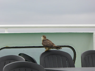
We went along to one of the briefings about the route and the flora and fauna of Patagonia.  Not overly exciting, but it did help us to identify the brown and black browed albatrosses and the steamer duck that we saw later in the trip.  I rather liked the steamer duck.  It doesn't fly, but it crosses that water by turning its wings in circles through the water, propelling itself along like a paddle steamer.  We saw a couple and recognised them by this very distinctive and somewhat amusing way of moving.  

We generally tried to avoid the entertainment though.  After the karaoke the first night, we were treated to a film on the second night.  Still not quite sure what was going on in the film, but it isn't ideal when you're in the bar and want to chat.  
 
Puerto Eden


And the third night we had the dual delights of bingo and a party.  This was so good that we and our stalkers put on our fleeces gloves and hats and sat outside on the deck instead!  Though not before we'd seen that winning on the bingo meant a Pontins style ritual humiliation of having to get up and dance to some dodgy tune before you could claim your prize.    

 But the scenery was pretty good.  A lot of it was general hills and mountains, but every so often you would have a beautiful snow capped mountain range, or pass through a narrow channel with little islands.

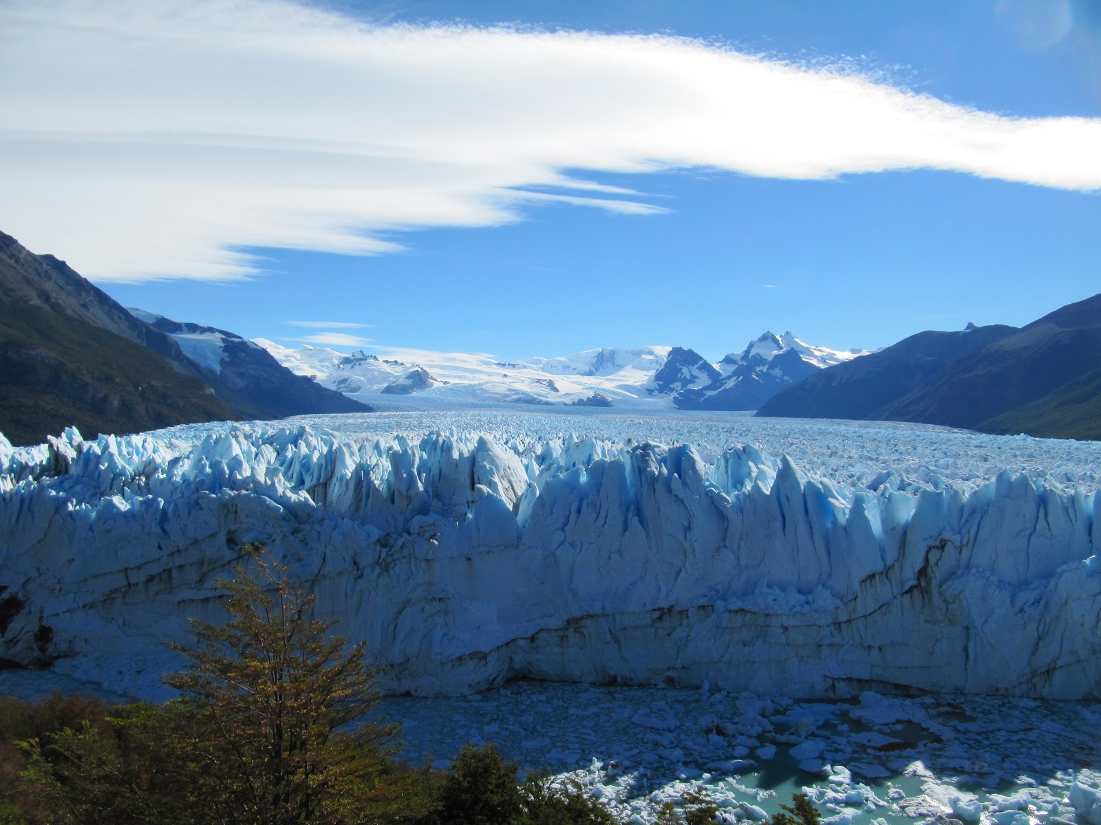
 The main attraction though was the Pio XI glacier.
Pio XI glacier


We took a detour into a glacier lake to see the huge glacier that was creeping down through the mountains and gradually melting into the lake.  It is apparently the largest glacier in South America and is 1265 squared km.  We could only see the end of it, but it was still pretty impressive.  With a mix of white green and blue colours, it had little caves eating into it and little waterfalls where streams ran through it.  It did look amazing. 

Capitan Leonidas

We also passed the Capitan Leonidas which is a wrecked ship that ran aground in the 1970s and now sits abandoned and skeletal in the Messier Channel acting as a warning beacon and covered with birds.


Albatross (I think!)

We also managed to spot a bit of wildlife along the way.  As well as the brown and black browed albatrosses and the steamer ducks that I mentioned before, we saw evidence of minke whales as they blew water jets into the air, other whales, penguins, and dolphins.  None were especially good sightings, and we didn't really get any decent pictures, partly because we are expecting better opportunities later, so we thought we'd just watch for now.
Lots of birds


We made our way through the Last Hope Fjord, so called because a ship trying to find the Magellan Strait to sail from the Pacific to the Atlantic in 1557 had failed in all its previous attempts and this channel was their last hope. It wasn't the right place do they failed again and gave up.
Penguin


However it was the right place for us, and we finally docked into Puerto Natales at seven pm, somewhat later than the advertised time of around midday, and made our way out through the bowels of the ship rather than having to wait while they unloaded the cargo.

Puerto Natales


Did the journey live up to it's expectations and price.  Well yes and no.  It was a good journey and we did see some nice scenery, and if this is the only chance you'll have to see scenery and wildlife like this then it is probably very good.

The Navimag Ferry


But it is really quite expensive, even if you take a dorm bunk, so whilst I would recommend the trip for itself, sadly I don't think it is good value for money.  But perhaps I would feel differently if we weren't in the lucky position of going to Antarctica later this year.